The Glasgow Context Server: A Wireless System for Location Awareness in Mobile Computing
Chris Johnson and Kevin Cheng,
Department of Computing Science, University of Glasgow, Glasgow, G12 8QQ,
Tel: +44 141 330 6053, Fax: +44 141 330 4913
johnson@dcs.gla.ac.uk, http://www.dcs.gla.ac.uk/~johnson
This paper describes the design and implementation of a low cost, context aware architecture for mobile Human-Computer Interaction. It builds on the active badge work of Olivetti and the PARCTAB system at Rank Xerox by exploiting recent developments in Personal Digital Assistants, in wireless networks and in infrared communications. The net effect is to enable users to keep track of their location and the location of others (who choose to disclose their position) without the need to wire-up an entire building. This avoids the significant installation and maintenance overheads that have limited the application of previous approaches. Our underlying architecture supports a range of office-based "follow me" applications. Print jobs can be redirected to the printer that is closest to the recipients’ current location. Documents can be transmitted across a network and cached so that they are readily accessed over a mobile network. There are also more "social" applications for this technology. The paper goes on to describe a pilot study which tracks the location of people within a shopping centre (mall). This enables parents to find their children or friends to find their partners. Companies can also use this technology to monitor the shopping habits of their customers. Finally, applications in healthcare computing are discussed. The system can be used to tarck the movement of clinical materials and even of patients within a hospital. It also offers significant efficiency benefits when linked to existing theatre management systems.
Keywords: mobile computation; ubiquitous computing; context awareness.
1. Introduction
Human computer interaction is changing. Increasing numbers of users are learning to exploit Personal Digital Assistants in addition to conventional desktop devices. The integration of these mobile and static systems creates a number of design challenges. In particular, many authors have argued that much is to be gained if we can increase the "context awareness" of mobile devices. For instance, wireless networks can be used to automatically retrieve documents that are relevant to particular meetings once the device detects that its user has entered a particular office. There are social uses. The GUIDE project has used context aware mobile devices to update information about historic sites as the user moves around a town centre (Rodden, Chervest, Davies and Dix, 1998). There are also domestic applications. Mobile devices can be used to control heat, lighting and sound as the user moves from room to room within their house.
Context awareness depends upon the mobile device being able to detect its geographical location. There are currently three means of achieving this:
This relies upon the system directly identifying the presence of the user. There are currently several international projects looking at the use of image analysis to support this. The ethical problems that are raised by this technology have recently been avoided through the use of tokens, such as ibuttons, and their associated readers. Users must then explicitly indicate their location by depositing the token in an appropriate reader each time that they change location. The drawback of this approach is that users frequently forget to explicitly indicate their movements.
This relies upon fixed transmitters that generate a unique identifiable signal, which has a precisely determined range. If a device detects this signal then it must be within the area, or cell, that is covered by the transmitter associated with that signal. This technique can be used to identify the gross location of a device within a GSM network. The Group Spatiale Mobile (GSM) infrastructure supports most of Europe’s mobile telephones.
This relies upon a number of fixed transmitters each generating a unique signal. If the device can detect those signals then it is possible to use a range of triangulation algorithms to calculate its position relative to the sources of those signals. This technique is at the heart of the Global Positioning System (GPS).
Designers can exploit a number of different technologies to support these two architectures. The utility of these technologies depends on the users’ environment and the resolution of the location information that is required. For instance, differential GPS can provide location information to within a meter. However, multi-path signalling problems cause satellite signals to deteriorate to the point where they cannot be used within most homes or offices. GSM signals only provide information to an accuracy of several kilometres but can be detected more readily inside buildings. In practice, however, GSM cell resolution is too coarse grained for many context aware applications. The following sections, therefore, focus on systems that provide mobile devices with the accuracy of GPS signals inside homes and offices.
2. Previous Approaches to Context Awareness
The last decade has seen a number of architectures for location aware applications. This section briefly introduces some of them. It is argued that their lack of success can be blamed upon two principle limitations. Firstly, that they have not been integrated with mobile computing technology. Instead, they have relied upon additional badges and other devices to communicate location information to desktop systems. Secondly, the supporting infrastructure that is required to provide context awareness has been too costly for many end users. Section 3 goes on to introduce a system that has been developed to avoid these limitations.
2.1 Infrared
Most context aware systems have exploited infrared technology. There are numerous advantages. Infrared transceivers are cheap. They are readily available and they have the short range required for a precise cellular resolution. Arguably the best known application that exploits this technology is the Active badge system (Harter and Hopper, 1994). This system relies upon a network of infrared "base sensors". People are located by wearing a badge that periodically sends out an infrared signal containing a globally unique identifier. In the final system, these badges had limited processing capabilities. They could also receive messages from the network of base stations.
One of the limitations of diffuse infrared signals is that they can potentially be received at many different positions within a room. The Active Badge system was, therefore, extended to exploit radio signals, see Section 2.3. Short-range transmissions are used so that the wearer’s position can be determined more precisely. This is then encoded and relayed back via an infrared transmission to the base station. However, this approach requires considerable initial investment to establish the necessary network of base stations that receive signals from each person’s badge. Each user is also required to wear a badge in a prominent position so that is can receive and transmit the necessary signals.
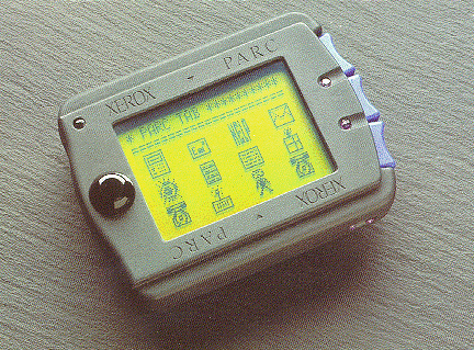
The PARCTAB system has many similarities with the Active badge approach. Again, infrared communications implement a cellular architecture. Users carry specialist devices that resemble pagers. As with the Active badge system, these devices communicate with fixed transceivers that are connected to conventional (wired) networks. The location sensing functionality of these devices is slightly more limited than the Active Badges. They do not support short-range radio signals (Want, Schilit, Adams, Gold, Petersen, Goldberg, Ellis and Weiser, 1995). However, it is important to emphasise that PARCTABs more closely resemble PDAs than Active Badges. This can be seen from Figure 1. Positioned over the display is a touch sensitive panel. The tab also includes three finger-operated mechanical buttons that can be used individually or in chords. Finally the unit includes a piezo-electric speaker that permits a number of different tones to be generated by applications.
Figure 1: A PARCTAB (Courtesy of Rank Xerox Corporation)
The Cyberguide system makes more limited use of infrared communications than the Active Badge and PARCtab approaches (Long, Aust, Abowd and Atkeson 1995). Rather than use a networked system of base sensors, this application simply used infrared transmitters to communicate a unique identifier for each location. A number of Apple Newtons and Palmtop computers were equipped with a specialist unit consisting of a separate infrared sensor and a Motorola 68332 processor. This architecture then enabled people to trace their position within a number of cells made up from the transmitters. No additional communications were required providing that the users’ mobile device was made aware of all of the identifiers for each of the transmitters before it was used. A number of further problems restrict the application of the Cyberguide approach. The use of custom made infrared unit, rather than the on-board IR ports of mobile devices, increased the costs of the system. The absence of independent wireless communications together with the passive nature of the fixed transmitters also prevented other users from obtaining any information about their colleagues. This imposes considerable limitations on the users’ view of their context.
2.2 Ultrasound
Most indoor context aware systems rely upon infrared transmissions to implement the cellular architecture that was introduced in the previous section. However, the BATS system is an exception (Harter, Hopper, Steggles, Ward and Webster, 1999). This approach relies upon the user carrying a device that contains a radio receiver, an ultrasonic transducer and associated controllers. It’s current dimensions are 5cm x 3cm x 2cm and it weighs only 35 grams.
This system also relies upon a number of ultrasound receiver units. These are placed on the ceilings of the rooms that are to be instrumented. Each receiver is connected to form a daisy chain of similar receivers. The BAT system also consists of a base station. This periodically transmits a radio signal that contains a unique identifier. The corresponding BAT emits an ultrasound "chirp" in response to this message. The closest receivers can then detect these "chirps". If three or more non-collinear receivers detect a signal then it is possible to triangulate the precise three-dimensional location of the BAT.
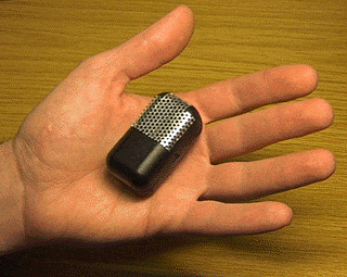
Figure 2: An Ultrasound Bat (Courtesy of AT&T Research)
As we shall see, this approach offers considerable advantages over the more widespread use of infrared signals. It is more accurate. "The finer granularity of this system in comparison to the Active badge enables us to provide more context information to applications, with consequent benefits to the user interface" (Harter, Hopper, Steggles, Ward and Webster, 1999). However, there are some drawbacks. In spite of the small size of the BAT, each user must still carry a dedicated object that conveys positional information. Perhaps more seriously, there is a considerable overhead is wiring each building to accommodate both the base station and the ultrasound receivers.
2.3 Radio Transmissions
Radio signals offer a further alternative to either ultrasound or infrared. This approach currently relies upon a cellular architecture. For example, Lucent’s Wavelan is a commercial mobile radio network. Each portable device communicates with a base station using a PC card that currently supports an effective bandwidth of 11Mbps. The base station typically has a range of approximately 100-200 meters depending on the construction of the building. It is, therefore, possible to gain a very rough approximation of the users’ position as they move between these relatively large cells. In the future it may be possible to triangulate a users’ position using the broadband radio signals. This would offer considerable advantages. The mobile network would connect the user to desktop resources and locate them within their environment. Unfortunately, this remains a subject of active research. The multi-path transmission problems that affect GPS and ultrasound signals cannot easily be resolved for broadband radio transmissions. In anticipation of the results of this research, the resolution offered by broadband radio signals is too large to support most context aware applications.
Lucent’s Wavelan represents one use of radio technology to support context awareness. The Bluetoot project represents another. "Bluetooth" is the codename for a short-range radio system that is being developed to link mobile PCs, mobile phones and other portable devices. The Bluetooth Special Interest Group includes Ericsson, IBM Corporation, Intel Corporation, Nokia and Toshiba Corporation, 3Com Corporation, Lucent Technologies, Microsoft Corporation and Motorola. Bluetooth connections are designed to work over distances of up to 2 or 3 meters rather than the 100-200 supported by Wavelan. From this it is readily apparent that it offers considerable potential for more fine-grained cellular architectures than those supported by the Wavelan architecture. Bluetooth is intended to be a standard for communication between mobile devices it also has the benefit that it is likely to become a feature of many different commercial products. Hence the additional cards required by even differential applications of longer range radio networks can be avoided. Unfortunately, there have been considerable delays in developing the Bluetooth standard. A Revised Version of the Bluetooth 1.0 specification was released while this paper was being drafted (06/12/99) and so it may be some time before we can buy devices that are equipped with the necessary hardware to exploit this approach to context awareness (www.bluetooth.com).
2.4 Electromagnetic Signals
It is possible to use electromagenetic techniques to provide location information for context aware applications. These systems resemble the applications that are used to protect the books in libraries and the merchandise in shops (Raab, Blood, Steiner and Jones, 1979). It is possible to identify a magnetic signature as it passes through a pair of detectors. These can be placed at strategic locations to monitor the user’s movements. For example, they can be placed at doors to detect the entrance or the exit of any item which carries the signature. This approach has a number of benefits. In particular, the stripes that carry the signature can be very unobtrusive. However, the detectors are relatively expensive and must be carefully positioned to provide the coverage that is required to trace a users’ changing location. There are further problems. For example, electromagnetic methods suffer interference from computer monitors and metal structures (Harter, Hopper, Steggles, Ward and Webster, 1999).
2.5 Direct Identification
The final approach to providing location information is, in many ways, the most obvious. Rather than using radio signals or infrared transmissions, it is possible to use image analysis techniques to identify individuals as they move around a building. Security cameras can be upgraded to give significant coverage without the overheads of rewiring an entire building. However, the technological and ethical problems with this approach are considerable. In all of the other techniques, it is entirely possible for users to "hide" their location for some or all of their activities. It is not clear how users might "opt out" from direct visual monitoring. An alternative approach is for the user to explicitly provide the system with location information. For instance, Georgia Tech’s Context toolkit exploits ibutton technology (Dey, Futakawa, Salber and Abowd, 1999). These steel-plated microchips provide 64k+ memory and a form of the Java virtual machine. They can be programmed to encode information about their owners. This can be read when the user inserts the button into a dedicated reader. Placing readers at various locations within a building provides location information. The relatively small size and weight of these "wearable" devices makes them an attractive alternative to signal detection. However, initial studies have revealed the problems of relying on the location information that can quickly become obsolescent as users "forget" to update their position.

Figure 3: The Java Ring Version of the iButton (Courtesy: ibutton.com)
Table 1 summarises this review. Some of the judgements must, necessarily, be subjective. For instance, the "Requires user action" refers to whether it is possible to detect the devices location without explicit intervention on behalf of the user. In some cases, such as the GSM row, the degree of user intervention depends on the particular context-aware application that is under consideration. Non-standard hardware is used to refer to any equipment that cannot be widely purchased by a designer wishing to implement a context aware application. It is also important to emphasise that the commercial opportunity of this area and its dynamic nature makes it very difficult to provide an exhaustive overview.
|
Resolution |
Fixed Network Overheads |
Requires User Action |
Effective Bandwidth |
Non-standard Hardware/ Software |
|
|
GSM - Mobile telephone |
500 meters – 6 km |
Low |
no |
13 kbps |
None |
|
Active Badge (Active IR) |
> 1 meter |
High |
no |
9.6 kbps |
Badge and base stations |
|
PARCTAB (Active IR) |
> 10 meters |
High |
no |
19.2 kbps |
Tabs and transceivers |
|
Cyberguide (Passive IR) |
> 10 meters |
Low |
no |
- |
External IR Receivers |
|
Ultrasound Bat |
> 1 meter |
High |
no |
- |
Radio masters, ultrasound chain, Bats. |
|
WaveLAN |
100-200 meters |
Medium |
no |
11 Mbps |
None |
|
Bluetooth |
> 1 meter |
Medium |
no |
1 Mbps |
Not yet available (12/99) |
|
Direct Video |
> 1 meter |
Medium |
no |
- |
Image analysis routines. |
|
Context Toolkit (Ibutton) |
(Depends on reader placement) |
Low |
yes |
- |
None |
|
Glasgow Context Server |
> 10 meters |
Medium |
no |
11 Mbps |
None |
Table 1: Summary of Location Detection for Context Awareness (indoors only)
3. GCS: the Glasgow Context Server
Table 1 reveals how none of the existing approaches provide effective means of obtaining high-resolution location information using "standard" hardware and software. The Glasgow Context Server has, however, been specifically designed to address these concerns. It successfully integrates an off-the-shelf radio Local Area Network with the infrared location sensors that have been a feature of many previous context-aware applications.
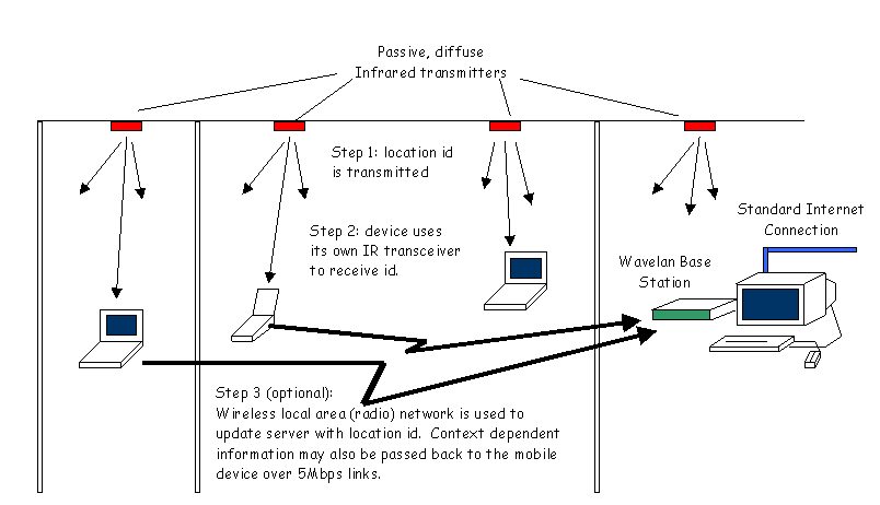 Figure 4: The Glasgow Context Server Architecture
Figure 4 shows how our architecture builds on previous work. Rather than adopt the active sensing techniques adopted by the Active Badge and PARCTAB projects, we follow the Cyberguide approach of using passive infrared transmitters that are mounted in the ceilings of any room or corridor. In other words, we use low powered, diffuse transmitters that do not directly detect the presence of other infrared transceivers. They simply send out a unique identifier. As mentioned, we are eager to exploit "off the shelf" options. To reduce costs, these transmitters can be based on domestic remote controls. The frequency of the signals can be identified using a range of commercial software that enables PDA’s to detect and replicate the infrared signals emitted by these low cost commercial devices. It is also possible to buy more advanced infrared controllers that can be used for the same purpose.
There are a number of reasons why we chose simply to transmit location identifiers rather than perform the active sensing of previous approaches. The most significant is that we wanted out system to be entirely mobile. In other words, no additional wiring should be required to install our system into a building. This is motivated by a strong desire to reduce both the cost and the complexity of our implementation.
PDAs and laptop devices can detect their location using their existing infrared transceivers. This avoids the external sensors that were a feature of the Cyberguide system. In its simplest form, the Glasgow system can operate without any mobile telecommunications. Location dependent information is cached on the portable device. As the user moves around the building and infrared signals are detected, applications can make use this data to tailor their presentation of information. A side effect of our architectural decision to avoid any additional wiring or processor support is that the user’s device will only update its location information when the user actually switches it on. This side effect also has a number of benefits. In particular, battery power is conserved. This is still a significant issue for many users of mobile devices who continually have to worry about the duration of their power supply. As we shall see, this design decision also helps to avoid many of the ethical issues associated with direct sensing. In order for colleagues to discover a users’ location, their machine must be powered and the user must explicitly indicate that they wish to reveal their position to the context server.
Perhaps the most innovative feature of our system is that it integrates infrared location detection with a commercial, radio-based, Local Area Network. In the current implementation, this is based around Lucent’s WaveLAN technology (www.wavelan.com). We chose this system for a number of reasons. Firstly, it is simple to install and operate. The user simply inserts a PC card into their mobile device and installs the relevant driver. From then on, the system provides a transparent network connection. The user notices no difference between wire-based and wireless interaction. The 11Mbps achieved by WaveLAN is particularly important in this respect. Installing a server is as straightforward but requires systems administrator privileges. The second key point is that WaveLAN technology has been approved by the UK Medical Devices Agency for operation in clinical environments, including NHS hospitals. This may seem a relatively trivial issue but users must be convinced of the long term safety of such technology. The third reason is that WaveLAN cards and drivers are currently available for a range of laptop and CE devices. They are currently not available for PalmOS. However, there are currently no commercial radio communications systems that support both of these technologies. This is a significant concern. If the context server were to support a heterogeneous range of devices then it may be necessary to support several proprietary radio systems or to provide access via GSM as a default but high-cost alternative.
The integration of a wireless local area network into the Glasgow Context Server provides numerous benefits. Not only can individual devices detect their position using the passive signals that are transmitted by the infrared technology, they can also use the radio network to communicate their position back to a central server. This illustrates a crucial benefit of passive systems. As the location transmitters have neither sensing support nor network connections, they cannot disclose the users position. Instead, the user’s device uses the mobile radio system to communicate location information. This effectively gives the user control over disclosure.
The "off the shelf" approach, described in previous paragraphs, offers significant benefits in terms of modularity. It is entirely possible to replace each of the components with alternative proprietary solutions. In particular, WaveLAN is only one of several mobile-networking solutions that can be used. Modularity is also apparent in the way in which this high-level architecture is independent of any particular software infrastructure. For example, location dependent information can be stored as distributed persistent objects using CORBA (Harter, Hopper, Steggles, Ward and Webster, 1999) or the language specific persistence of P-Java (Spence and Atkinson, 1997). At present, the Glasgow Context Server builds on recent work at the AT&T research laboratories by exploiting the former approach referenced above. However, there are considerable limitations when using this approach to maintain quality of service over distributed, mobile systems especially when contact may be lost with the user’s colleagues (Cheverst, 1999). CORBA provides no explicit support for ensuring a quorum of users. Nor does it enable interactive applications to detect limited network connectivity amongst the members of a work group. This is very much an area for further work and remains a focus for collaboration and discussion amongst many of the researchers responsible for the context aware systems identified in Table 1.
The integration of radio-based local area networks and passive infrared location sensing offers many benefits. In particular, the decision to reject any fixed network solutions means that the system can rapidly be installed into environments where it is difficult or impossible to install more conventional systems. The following section describes how we are working on a number of commercial applications of this technology. These go well beyond the conventional office domain of "follow me" systems that offer call forwarding and printer redirection. In particular, we are keen to extend context awareness to support human computer interaction in both clinical environments and into shopping malls.
4. GCS Applications
The Glasgow Context Server has a number of unique features. In particular, it is the first context aware system that exploits fully mobile technology. Even the wireless base station can be driven from a laptop. This creates the flexibility to install the system in a number of work domains that have not previous been considered as potential applications for location sensitive interfaces.
4.1 The Office Domain
Previous sections have referred to the "follow me" applications that have previously been developed using location aware technology. These have enabled phone calls and faxed to be automatically directed to the room in which a user is currently located. They have enabled people to automatically re-route print jobs to the nearest printer. They have also enabled individuals to locate groups of co-workers within a building that supports Active Badges and PARCTABS. In many ways, it is surprising that such applications have not received wide commercial success. We have argued that some of this is due to the significant installation overheads that are avoided by the mobile architecture of the GCS. It may also be due to individual reluctance to carry additional devices such as Bats and badges. GCS avoids this aversion by exploiting the PDA’s that are now carried by many people. We also intend to expand our approach to use the infrared transceivers that are a standard component of most mobile telephones.
Perhaps a more deep-seated reason for the lack of market penetration by context aware applications is that there are insufficient benefits to outweigh the costs of these systems in the office environment. We have, therefore, chosen to focus the application of the GCS to working domains that are not traditionally associated with this form of human computer interaction.
4.2 The Shopping Mall
Two novel application areas for the GCS are based in retail outlets or shopping malls. The first focuses on providing retailers with information about their products and their customers. We have also experimented with placing ruggedised PDA’s into shopping trolleys. As the customer moves, the PDA picks up the IR location identifiers from the passive transmitters described earlier. As no cabling is required we can potentially install the system to cover an entire hyper-market in under two hours. The ambient lighting conditions of these environments do create some problems. It is, however, relatively straightforward to overcome these limitations by careful placing of the low-cost transmitters. This architecture enables us to track customers as they move both within a shop and between other shops in the same mall. This information cannot simply be obtained by reading the location information that is implicit within a customer’s till receipt or hand-held product scanner. It is often more important to determine those areas of a shop that a customer chose to visit but did NOT choose to purchase than those areas which a customer did buy products from.
The second focus for our retail work centres on providing information to customers. In it’s most primitive form, we have extended the GCS to show customers their current location within a shop. This is simply calculated by identifying the current IR cell in the manner described in previous sections. Information about the layout of the shop can be cached on the device so that the customer can then navigate their way to the goods or services that they require. The provision of a radio link also makes it possible for the system to automatically reconfigure layout information as the user moves from shop to shop. There is a wide range of other applications for the GCS architecture. These build on the pioneering work of the GUIDE project. For example, mobile links can be used to automatically alert the user when their dry cleaning or photographs are ready for collection. They can also be used to provide the user with information about complementary goods and services. If the user requests information about the location of haggis then the system can provide information about the location of traditional accompaniments to this Scottish delicacy (turnips and potatoes).
A current focus for this research is in the application of our system to help users find friends, partners and children in increasingly large and complex shopping malls. The low overheads associated with the installation of GCS supports the extension of the Active Badge ideas to these more prosaic concerns. The increasing bandwidth supported by WaveLAN and similar technologies make it technologically feasible to transmit both audio and video signals between standard PDA’s. The areas equipped with GCS will, therefore, avoid the additional costs associated with transmitting such information over proprietary telecommunications networks.
4.3 Anaesthesia
Much of our research has been driven by the need to improve the accuracy and availability of information in clinical environments. The GCS architecture partly developed from our involvement with the Paraglyde project. This EPSRC initiative aims to provide anaesthetists with patient information during post-operative care. In these situations, it is critically important to support the flow of information between clinical and nursing staff. Mobile telecommunications enable information to be passed between nursing staff and an anaesthetist who may already be working on another case. The additional of location sensing technology enables nursing staff to locate anaesthetists as they walk between the departments of a hospital. It is important to emphasise that this technology also offers considerable efficiency savings. We are integrating the GCS into some of the existing theatre management systems. This enables clinicians to be continuously updated about their colleague’s progress with an operating list and hence the likely availability of that theatre for subsequent operations.
The flexibility of the GCS approach, together with the Medical Devices Agency approval for WaveLAN technology, also enables context aware computing techniques to be provided in other clinical settings. For example, IR transmitters can be located within each ward so that relevant patient information is automatically transmitted and cached when a clinician arrives on a ward. We have made some initial steps towards the use of this approach in pre-operative settings. The anaesthetist must complete a preliminary survey of the patient’s suitability for a particular procedure. Prior to doing this a brief summary of the patient’s medical history can be transmitted to the anaesthetist’s PDA using the WaveLAN link. The PDA also provides an interface to a preliminary assessment form that the clinician then completes in consultation with the patient. The radio link is then used to communicate the completed form back to personal and central records.
It is important to emphasise that clinical environments have revealed both the strengths and the weaknesses of the GCS. The use of mobile, wireless connections enables us to rapidly cover buildings that cannot easily be disrupted by wiring activity. The GCS architecture has enabled us to design solutions to a wide range of clinical tasks. However, there are many tasks that cannot adequately be support by the passive approach that we have described and which could be better supported by the active Bats and Badges technology. For example, GCS works by locating PDA’s in relation to fixed IR transmitters. This makes it difficult to trace the location of objects such as clinical samples as they move around the hospital. Perhaps more prosaically, but equally importantly, the GCS architecture makes it difficult to track patient movements as they move from department to department unless they are carrying a PDA.
We have, therefore, begun to develop a more general approach that continues to exploit passive location sensing techniques. This depends upon two different forms of IR transmission. It should be noted, however, that the transmitter hardware is identical. The first generates the fixed, location dependent signal shown in Figure 4. The second form of IR transmitter is attached to mobile but inanimate objects, such as a batch of clinical samples. The intention is that the location of these objects can be requested by a clinician by using their PDA and WaveLAN link to contact the context server. Any PDA that is actively connected to the system can then listen for the signal from the mobile IR transmitter that is attached to the object. Battery power limitations can be reduced by using the radio network to request a cell specific IR transmission from the object in a manner similar to that developed for the Bats described earlier (Harter, Hopper, Steggles, Ward and Webster, 1999). More work is required to achieve this. However, if a PDA can identify the IR signal from the requested object then it can respond to the server’s request with it’s own location. This can then be transmitted back to the clinician. A drawback of this approach is that it requires another mobile device to be active and in the same cell as the object in order to detect its IR signature. For most applications this does not provide users with the required level of assurance that their query can be answered. One solution to this problem is to resort to active, networked IR transceivers as was done with the Active Badge and PARCTAB systems. However, this runs against the approach adopted in this paper. We are keen to avoid the cabling associated with active systems. Again, the solution is simple. In locations where it is important to reliably locate an object, for instance in a pathology lab, it is usually possible to locate a desktop device. Many of these are networked and can readily detect the signals from an IR tagged object. Those machines that are not already networked can be equipped with their own "stationary" WaveLAN card. It is ironic, if unsurprising, that this often provides greater bandwidth at a lower cost than the fixed networks which are currently operating in many of this countries public institutions.
5.Conclusion and Further Work
This paper describes the design and implementation of a low cost, context aware architecture for mobile Human-Computer Interaction. It builds on the active badge work of Olivetti and Rank Xerox by exploiting recent developments in Personal Digital Assistants, in wireless networks and in infrared communications. The net effect is to enable users to keep track of their location and the location of others (who choose to disclose their position) without the need to wire-up an entire building. This avoids the significant installation and maintenance overheads that have limited the application of previous approaches. Our underlying architecture supports a range of office-based "follow me" applications. Print jobs can be redirected to the printer that is closest to the recipients’ current location. Documents can be transmitted across a network and cached so that they are readily accessed over a mobile network. There are also more "social" applications for this technology. The paper goes on to describe a pilot study which tracks the location of people within a shopping centre (mall). This enables parents to find their children or friends to find their partners. Companies can also use this technology to monitor the shopping habits of their customers. Customers can use this technology to locate goods and services within increasingly complex retail environments.
Acknowledgements
Thanks are due to the members of the Glasgow Interactive Systems group who provided valuable help and encouragement with this research. I am also grateful to Greg Abowd at the Georgia Institute of Technology for his valuable advice and encouragement in the drafting of this paper. Thanks are also due to Andy Hopper, Andy Ward and their colleagues at the AT&T Cambridge research labs for initial advice with this paper.
References
Keith Cheverst, Development of a Group Service to Support Collaborative Mobile Groupware. PhD thesis, Department of Computing Science, University of Lancaster. 1999
A.K. Dey, M. Futakawa, D. Salber and G.D. Abowd, The Conference Assistant: Combining Context-Awareness with Wearable Computing. In the Proceedings of the 3rd International Symposium on Wearable Computers (ISWC '99), San Francisco, CA, October 20-21, 1999. pp. 21-28.
A. Harter and A. Hopper, A Distributed Location System for the Active Office. IEEE Network, Vol. 8, No. 1, January 1994
A. Harter, A. Hopper, P. Steggles, A. Ward and P.Webster, The Anatomy of a Context-Aware Application. In Proceedings of the 5th Annual ACM/IEEE International Conference on Mobile Computing and Networking (Mobicom '99), Seattle, Washington, USA, August 15 - 20 1999 1999.
S. Long, D. Aust, Gr. D. Abowd and C. Atkeson. Cyberguide: Prototyping Context-Aware Mobile Applications. CHI'96 Short paper, December 1995.
F. Raab, E. Blood, T. Steiner and H. Jones, Magnetic Position and Orienting Tracking System. IEEE Transactions on Aerospace and Electronic Systems, Vol. AES-15(5):709-718, 1979.
T. Rodden, K. Chervest, N. Davies and A. Dix, Exploiting Context in HCI Design for Mobile Systems. In C. Johnson (ed.), Proceedings of the First Workshop on Human Computer Interaction with Mobile Devices. Technical Report G98.1, Department of Computing Science, University of Glasgow, 1998. Available via http://www.dcs.gla.ac.uk/~johnson/papers/mobile/HCIMD1.html
S. Spence and M. Atkinson, A Scalable Model of Distribution Promoting Autonomy of and Cooperation between PJava Object Stores. In IEEE. Proceedings of the International Conference on System Sciences, Aston Wailea Resort, Wailea, Hawaii, USA. 7-10 January 1997.
R. Want, W. Schilit, N. Adams, R. Gold, K. Petersen, D. Goldberg, J. Ellis, M. Weiser, An overview of the PARCTAB ubiquitous computing experiment. IEEE Personal Communications. 1995 December; 2 (6): 28-43. 1995.